in which we commence the
major part of our Canadian sojourn
 |
| Squamish to Penticton |
Squamish to Pemberton
What were we thinking?
The day started cool but fine. A relatively early start meant that we cleared Squamish before too much traffic was buzzing around Squamish. A flat first 8 kms or so would be followed by a long gradual ascent to Whistler, and then a nice descent into Pemberton. Here's what the route and its profile look like:
After having a very enjoyable couple of days off the bike in Squamish, we'd forgotten that our itinerary had us stopping the night in Pemberton. (I know: "How could they do that," you're wondering. Don't worry, we're still haven't worked out how that happened too. Maybe because on these long trips we're not used to only riding 45 kms each per day. Like I said, still trying to work that one out. 🤔
With dull conditions there wasn't a lot to photograph along the the first part of the journey, but crossing above the railroad at one point a classic Gordon Lightfoot song came to mind and stuck there for the duration of the ride ...
 |
| "There was a time in this fair land when the railroad did not run" |
Coming into Whistler I decided I should take a photo of the sign ...
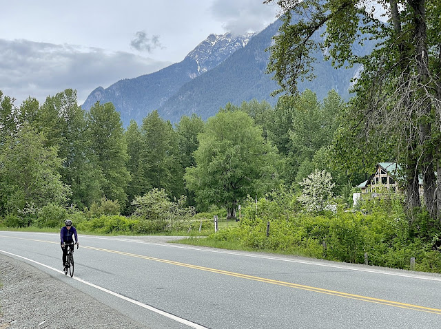
Scenery really only started to appear once past Whistler. Here's a photo of the first big lake north of Whistler, where I met Di for a bit of food and water ...
We were starting to see more of the mountains as the cloud cover lifted ...
Thinking that we were riding through to Lillooet. we agreed that I'd ride the first leg to Pemberton and then Di would have two rides: a nice flat ride along the Lillooet River, and a descent into Lillooet after getting a lift up the big hill between Pemberton and Lillooet. It was very cold up high descending along Cayoosh Creek so in the end she decided to climb off the bike at the eastern end of Duffy Lake. Here's what her ride looks like on Strava, with the straight bit in the middle showing when her GPS was turned off while she rode in the car ...
The riding along Lillooet River was very nice ...
... and it was very clear where the big climb started ...
Once at the top of the big climb (well, just under the top as it turned out) Di added another layer for warmth - it was about 4 degrees C - got ready to roll once again ...
There wasn't a lot of sunshine but it wasn't windy and the visibility was good ...
I was a little naughty and shot a short bit of footage through the windscreen with my GoPro ...
Cool runnings but still very nice riding
There was some very nice forest along the way ...
Before very long Duffy Lake appeared ...
About halfway along the lake there was a significant logjam where the lake narrows ...
Pemberton to Lillooet
A Bonus Team DB Ride Followed by a Fun Run to Lillooet
 |
| A Team DB/Southern Pedals Ride ~ Yippee! |
Delay of Game/Extended Warmup
It was raining when we roused ourselves at our substandard motel in Pemberton. Raining when we packed up. Rain easing when we went in search of coffee. But as we were searching it seemed to be clearing in the valley at least. I suggested we drive out Pemberton Meadows Road - which I'd spotted on RideWithGPS as possibly a nice place for a little spin - and check it out.
What we found was a beautiful river valley surrounded by soaring mountains. Here's a map with the road highlighted in red ...
 |
| Pemberton Meadows Road |
And here's a satellite view of what the terrain looks like from space ...
 |
| Pemberton Meadows from space |
After just 5 kms or so of scouting by car we were both bursting with excitement at the opportunity to ride together down on the flats while the weather cleared - which was what it was forecast to do - on the heights.
And here are some photos to illustrate the ride ...
 |
| I'm thinking that this must be the "Riverlands Red Barn" property show on the map above |
 |
| Not clear by any means, but at least the road is dry - at this stage! |
 |
| A side stream flowing into the Lillooet River |
 |
| On the way back and the sun is shining! |
Unfortunately, shortly after I took the photo above the clouds closed in again and it started raining ~ just enough to get our bikes - and us! - fairly dirty from the water and grime on the road. Here's what Di's bike looked like when we got back to the car ...
 |
| Di's bike after our ride out past Pemberton Meadows |
We could scarcely care that we'd gotten a bit damp and dirty because we'd got a ride in - a joint ride that was unexpected. Even if the conditions were not nice enough to enjoy cycling towards Lillooet we'd had a great time already.
On to Lillooet
 |
| The ride/drive relay from Joffre Lakes to Lillooet |
As Dianne had already the flat section out to Lillooet Lake and neither of us felt like riding up the big hill we drove up to the turnoff to Joffre Lakes which is a very popular hiking and mountaineering destination. I got the first bit because Di had got back on the bike hereabouts the day before. There was no snow on the ground beside the road at the top of the hill but it wasn't that far uphill either. It was clear but cold - around 4 degrees C - when I set out. At least it wasn't windy.
 |
| Jacket over a long sleeved jersey and warm gloves kept me warm |
 |
| Cayoosh Creek |
The road from the top of the hill near Joffre Lakes all the way down to Seton Lake just before Lillooet. There is a net descent of 1000 metres over a distance of about 65 kilometres.
 |
| It did gradually get warmer as I descended (honest!) |
 |
| A beautiful road steadily descending + little traffic + verdant forest equals BLISS |
 |
| Pretty much done looking at snow now |
This route is still the same highway 99 that starts south of Squamish at Horseshoe Bay. Here it is known locally as the Duffy Lake Road, and for tourist purposes gets the designation as the Coast Caribou part of the Discovery Coast Circle Route. Sounds all a bit complicated to me. I do like the sign above though.
My arranged stopping place was about two-thirds of the distance to Lillooet, at a place called the Cinnamon Recreation Area. Di had said she probably wouldn't get back on the bike but, seeing how much fun I was having and noting how the temperature had warmed up she decided to hop on the bike for the final run into Lillooet. Here are a few photos of her on the road and the scenery she enjoyed from the saddle of her steed ...
 |
| Working hard on one of the climbs that add spice to the overall downhill |
 |
| The car on the right has seen her coming and gotten out of the way! |
 |
| Di paused halfway up the little hill into Lillooet for this photo of the Fraser River |
Lillooet to Cache Creek
A Small Town with Character
Before talking about our traverse further inland it's worth pausing for a moment to look at the town of Lillooet on the mighty Fraser River. Although quite a small town, it has a rich history. Indigenous people have occupied the area for a very long time, living well off native flora and fauna - especially salmon migrating upstream.
One of the more interesting aspects of the area's history is its connection with jade. Aboriginal people carved tools from jade, with Lillooet recognised as a major centre of jade deposits. But it was the Fraser River gold rush that really put Lillooet on the map. Some historians say that in 1858 when the gold rush was at its height, Lillooet was the largest city in North America west of Chicago and North of San Francisco.
Today Lillooet is a quite little town, but it has perhaps the best bakery we've visited since we arrived in Canada. Here are some reasons why I say that ...
 |
| A Bun Dance ~ great name for a bakery I reckon! |
The A Bun Dance bakery prides itself on its sourdough breads and other products using primarily locally produced ingredients.
 |
| A nod to the history and traditions of the area |
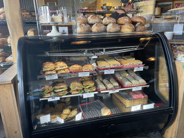 |
| Would have liked to take one of the rolls but wouldn't fit so well in a jersey pocket |
 |
| Does that bread look good or what! |
 |
| Croissants, Pain au chocolat, Danish pastries, CINNAMON BUNS, and ... more! 😁 |
 |
| Cinnamon bun (fabulous) and a great cup of coffee |
As it turned out, I also got one of the best cups of coffee I've had since I arrived in Canada on the 3rd of May at the A Bun Dance Bakery. A final word on bakeries in Lillooet: it appears that there were once two other bakeries in the town but both are closed. No wonder with such a tour-de-force arriving in town.
Di's Delight
After breakfasting it was back to the hotel to get into our cycling kit and on the road. Di was up first and I must say she got the best part of the route to ride today, which was nice. After the descent back out of Lillooet she crossed the Fraser River ...
 |
| The mighty, silt-laden Fraser River |
... and pretty much immediately started up into the hills on the other side ...
 |
| Looking down towards the Fraser. Terraces on the right are for avalanche containment |
 |
| Powering along past an overpass for the Canadian National railway line |
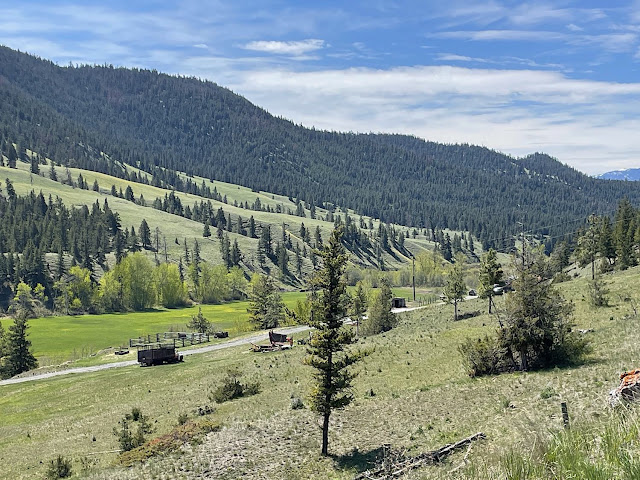 |
| Typical Caribou Country scenery |
 |
| More Fraser River benchland |
 |
| A rustic gate with a natural handle just near the end of Di's ride |
A Slog to Cache Creek
Di had had the benefit of a tailwind for the most part, but by the time I got to get on the bike she'd turned into the wind and, to be perfectly honest, I found my ride through to Cache Creek a bit of a slog. At least it was warm. Here I am a little way along the way ...
 |
| Off the Coast Circuit and on to the Heritage Discovery/Lakes & Trails |
 |
| Trees are less densely packed in these parts |
 |
| Lots of broken down old homesteads along the way |
 |
| The historic Hat Creek Ranch is located at the junction of highways 99 and 97 |
And here's the turnoff to highway 97, which will take me into Cache Creek. Unfortunately, the remaining 10 kilometres were straight into a block headwind ...
 |
| Turn right here |
I was glad to finally arrive at our accommodation ....
... which was in a great log building ..
 |
| The Bear's Claw Lodge, Cache Creek |
They have a nice rustic dining room ...
... but like so many business suffering the effects of COVID can't get staff, so they are unable to offer meals.
Cache Creek has never been a vibrant, cosmopolitan place but it is much depressed since we were here last. Many businesses, especially eateries, are shut and most of those that remain open are running on a shoestring staff. The immediate future at least does not look very bright for this largely overnight motel and truck-stop town.
Cache Creek to Kamloops
Cache Creek is on the Trans-Canada Highway so there's lots of heavy traffic passing through at speed. We had a plan to drive out of town to Boston Flats and start our ride/drive relay there. It's pretty much all ranching country hereabouts without much change in scenery ...
 |
| Wide open vistas |
... but it was still pretty easy on the eye, especially at this time of year when everything is still pretty green.
In which I Continue My Affair with the Headwinds
I was up first and the ride started with a flattish section before dropping down to the old town of Ashcroft. There the Thompson River is crossed before a long climb up onto a plateau. My ride would finish with a descent to Logan Lake. Here's what my route looks like ...
 |
| Boston Flats to Logan Lake |
The wind was from the south. It was slow going until I got to the nice little descent to Ashcroft where I managed to pick up a bit of speed and cross the river. Di paused in Ashcroft while I started to do battle with the hill - and the now gusting headwinds. She got some nice shots photos down there in the historic riverside town ...
It wasn't long before she caught up to me, battling with the gradient and a steady headwind ...
 |
| Little Aussie Battler? 😬 |
The hill went up in two steps separated by about a kilometre of flatter ground: 2.5 kms at 6% and 11 kms at 7.5%. Maximum gradients were 14%.
There was a large trailer loaded with hay bales where the gradient eased off.
I wondered at this. Had the vehicle towing it broken down just as it reached the easy bit? But then once my brain got a bit more oxygen pumping around, I thought perhaps it was towed up the hill by a powerful vehicle and left to be continue its journey tethered to a lighter vehicle. Who knows?
In any case I was very happy when I reached the long section where the incline eased back to 1-2% for the next 5 kms ...
 |
| Oh man. That is so much better |
Once up on the plateau the riding became so much easier, with a little protection from the wind provided now and again by trees alongside the road.
On the way to Logan Lake I rode past a very sobering sight. Highland Valley Copper Mine is the largest open pit mine in Canada and one of the largest in the world. Via Google Earth Pro, here's what the mine looks from an elevation of over 50 kms above the Earth's surface ...
 |
| Highland Valley Copper Mine: a sobering sight |
I had a good run down the hill to Logan Lake but had to keep an eye on things. The wind had picked up and was coming from my right flank, occasionally swinging more to a crosswind. It was good to arrive at Logan Lake after a fairly challenging ride and two days of mostly headwinds.
Flying Dianne: Disaster Strikes!
Di's ride from Logan Lake to the outskirts of Kamloops mapped out on RideWithGPS at just over 52 kms, with 560 metres of ascent and 930 metres of descent. We had her stopping on the outskirts so she wouldn't have to negotiate a lot of traffic to our motel room at the other end of town.
Here's what the route looks like ...
 |
| Click on the image to see the size of the grin |
 |
| Grass bowing to the power of the wind |
... and even small trees were showing the effects of the wind as it had started to get quite strong ...
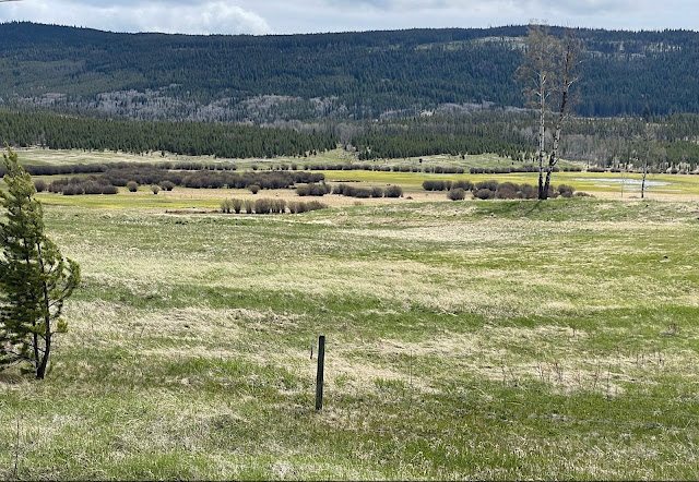 |
| Check the wind shape of the small tree on the left of the photo |
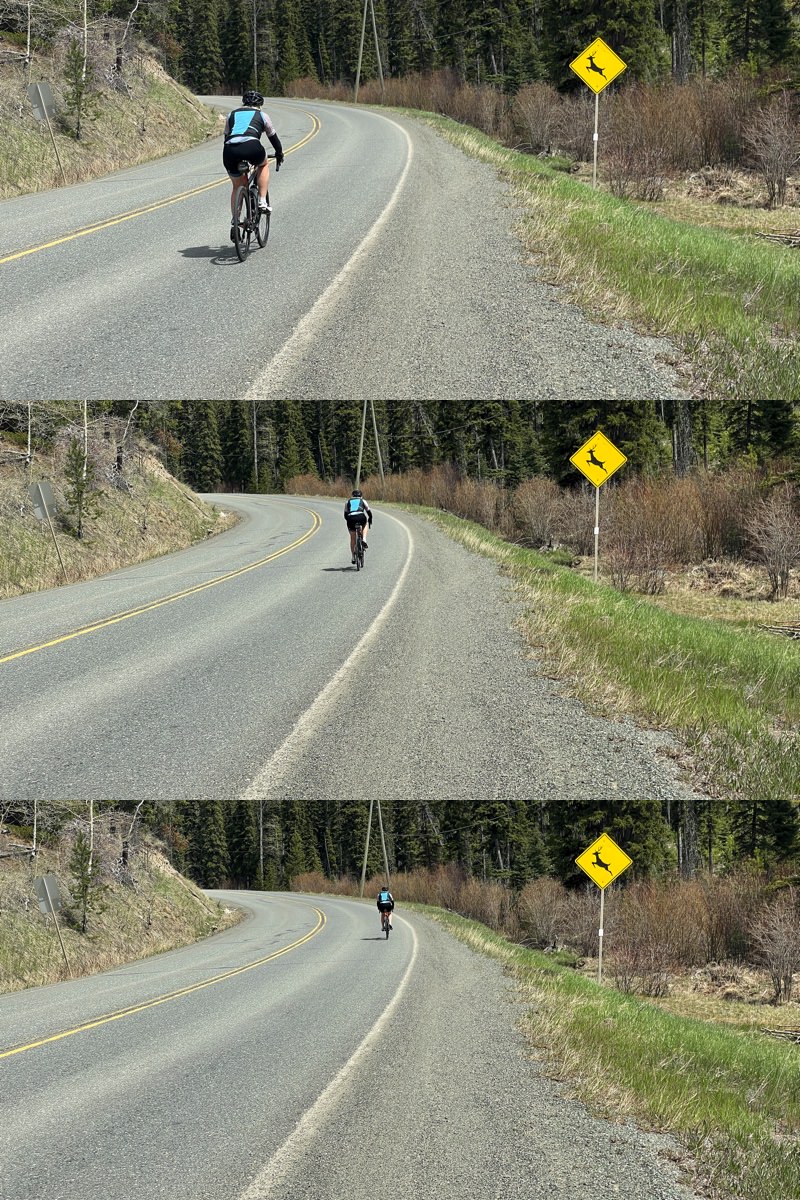
The road started to descend, fairly gradually at first and Di started to gain more speed with the wind behind her ...
Further up the road I paused to watch her flying past a warning sign for deer crossing the road ...
She was really starting to pick up moment now at the beginning of a long, long descent and was really flying.
Around the corner I passed her so I could look for another photo opportunity. Now, slowing down so she could catch up, I became a little puzzled - and then non-plussed - that she hadn't appeared in my mirror descending the long straight behind me.
After another bend and a few hundred metres further down the hill I decided I better go back. Almost as soon as I turned around a black pick-up was coming towards me with its lights flashing. Di had crashed (it's hard writing this) at about where the black spot is on the map above, 37 kilometres into her ride with all downhill riding in front of her. It seems that she was knocked off line by a strong side gust and couldn't arrest the wobble that created.
My heart fell out of my chest when I saw her by the side of the road, but then my spirits lifted slightly when I realised that she was actually sitting up. That was something at least.
From her Strava post, this is the graph of her speed for the ride ...
 |
| Speed in blue; route profile shadowed in grey |
If you're astute you'll have noticed that the ride ends with a very high speed. Di's GPS recorded a highest speed of 72 kms/hour which paired with the graph shows that happened at the end of her ride.
It's very hard to imagine that someone could come off a bike at that speed without some significant damage. She was in significant pain and my first concern was that she not go into shock, so I went to the car and got something warm to drape over her. Two drivers had stopped their vehicles. One had just gotten Di's bike off the road and was looking after her while the other was doing traffic calming. The second of the two had called for assistance from a paramedic working on the pipeline that is being installed across BC from Alberta.
The paramedic - Christine was her name - arrived quite quickly and got Dianne into her "treatment centre". It was another hour or so before the ambulance arrived and Di was taken to hospital. Various tests and scans were performed, revealing no internal injures or damage to the spinal cord, but that Di had broken two ribs and her collarbone. We needed to spend two more nights in Kamloops so Dianne could have a consultation at the fracture clinic. We spent those two days going over various scenarios about what we should do, depending on the outcome of the consultation. However, unlike Mulga Bill whose escapade was more of a fright that anything more significant, she remains undaunted. She has already started to entertain the idea of some rides on our gravel bikes once we're home and her bones have repaired themselves
The orthopaedic surgeon she saw first thing on Monday morning recommended Di not have her collarbone pinned. It seemed like a good idea to have another day of rest before we moved anywhere. Dauntless Di, ever determined, was adamant that we continue our "holiday". We rejigged our itinerary that night and set off for Vernon the next day.
With the Invalid in Kamloops
 |
| Sculpture alongside the Thompson River |
For the first couple days in Kamloops Di did a lot sleeping and got out for short walks. She insisted I get out of her hair and on my bike during this time. Couldn't really argue with that. We also did a few short walks together along the river. It might look like she's jogging in the photo above but that is just her normal walking stride, which I have difficulty matching.
I had three excellent rides during our sojourn in Kamloops. Two of them were out along the North Thompson River ...
 |
| Farmland along the river flats |
... a beautiful bit of cycling on an extremely quiet country road. Every once in a while a car or a truck would go by ...
 |
| Beautiful Westsyde Road; little traffic |
A new pipeline is being built to transport oil from Alberta to Vancouver (which is in financial difficulty) and quite a lot of construction is ongoing around Kamloops at the moment. In the background of this photo of an old shack you can see a pickup truck and some disturbed ground where the pipe is being laid ...
 |
| Decrepit shack; pipeline construction in the background |
About 20 kilometres away from the start of the road I was captivated by this sign along the road ...
There was also this little copse of trees ...
 |
| I think these are poplars |
Just before I was about to turn around at the top of a little rise a guy passed me going the other way, at a moderate pace. I did my 180 and gradually caught up to him. We started chatting ...
 |
| A new found friend |
... and rode together back to where I'd parked the car. Peter Nick is a bit of a local legend and was doing a cruisy century, having ridden up the east side of the river before crossing on the Mclure Ferry, just a bit north of where I'd turned around. Back at the car we exchanged details and arranged to meet up for another ride the next day - this time on the other side of town along the South Thompson River.
It was a beautiful still morning when we set out ...
 |
| Still conditions on the South Thompson River |
Coming back towards Kamloops on the other side of the river we passed an old feed lot covered in rogue canola ...
Peter told me that he often sees a herd of bighorn sheep on the slopes above the road and below the tottering cliffs above known as "hoodoos" in this part of the world (which my friend Jon tells me are made up of glacial lake silt and clay). There weren't any sheep today but the hoodoos are impressive in their own right ...
We stopped near the river for a bit of history and I took this shot of the two of us ...
 |
| Peter is a proud cycling lumberjack and wears a jersey to prove it! |
Between us and the river is this monument showing different flood levels ...
 |
| The flood levels shown for top to bottom are 1894, 1972, 1948 and 1999 |
Not long before we left Kamloops, by accident we came across the Kamloops Indian Residential School where so many indigenous children were so badly neglected and abused ...
Using ground-penetrating radar, Dr Sarah Beaulieu - a modern conflict anthropologist - has determined that approximately 200 bodies between the ages of 3 and 15 were buried in unmarked graves on the site of the Kamloops Indian Residential School which is situated on a beautiful site on the South Thompson River, just before it meets the North Thompson River to form the Thompson River ...
It was a very sobering last taste of Kamloops.
Kamloops to Penticton
We had a walk and then a late start leaving Kamloops because we only had to drive about 125 kms for the day to Vernon. I'd ridden out to the east a couple of days earlier with local cycling identity Peter Nick and he'd shown me a beautiful way to avoid riding much along the highway for 20 kilometres or so. After looking closely on RideWithGPS I then discovered Barnhartvale Road, allowing us to further avoid driving on the highway for another 10 kilometres or so.
 |
| Our route from Kamloops to Vernon |
We spotted six cyclists along Barnhartvale Road: a solo male bikepacker; four women also bike packing; and a solo male road cyclist on a racing bike. I was quite jealous as it was such a gorgeous road, winding, rising and falling and almost devoid of traffic. I made myself stop and get out of the car to take a photo for posterity ...
 |
| If you click on this image above you might be able to see how the road winds along |
If I am ever back in this area I will definitely make a point of riding from Kamloops to the end of Barnhartvale Road and back again. It would make an outstanding day ride.
As we were nearing Vernon Di googled "best Ukrainian restaurants Vernon" because we'd been through here before a number of times on past trips to Canada. I have Ukrainian heritage and have introduced Di to the delights of pirogies and cabbage rolls. The first one sounded just fine and it was on our way to our hotel so we headed that way. Excellent decision. Food was great and plentiful enough to have the rest for dinner later. And there were some charming reminders of Ukrainian culture on the walls ...
The next day was another highlight. We'd arranged to stop at Kelowna on our way to Penticton to have lunch with Auntie Flo, my Mum's younger sister. Dianne and I have had many great visits with Flo and my Uncle Eddie on previous trips to Canada and we were really looking forward to catching up. She'd insisted on cooking lunch for us rather than allow us to take her out because that way we'd have more time to catch up. And the bonus: my cousin Janice who we hadn't seen for decades and has moved back to Kelowna would be there too.
We were so busy catching up with the two of them we forgot to take a photo to commemorate the event so I asked Flo if she had a picture she could send me for the blog. It's not very recent but it illustrates well what good fun the two of them are ...
 |
| Janice and Flo |







Doug and Dianne, your cycling adventures are absolutely fascinating and made so real by your blogging. For me, it's a vicarious cycling experience, especially since I've never been to Canada. What an absolutely pristine area you've chosen for this holiday!
ReplyDeleteI must say that I was saddened by Di's crash, but amazed at her spirit that always seems to allow her to move forward. Cheers to you, Dianne.
Thank you both for being the intrepid and entertaining adventurists we all would expect from you two. Looking forward to more of your blogs, but also to knowing that Dianne is on the fast track to recovery.
Bruce McVicker
Many thanks for your comments Bruce. Di has had a much better day today and I think she is finally on the up. It will be great for her to get a week in one place to rest up and gradually increase her activity levels.
DeleteCheers
Doug
Doug very sorry to read of Di’s crash, do hope she continues to be comfortable. We spent some time in Penticton some 20years ago visiting good friends from Dungog who were doing a teacher swap for a year, a great area. we had driven up from LA and East from Seattle. Take care JD
ReplyDeleteThanks John. Yes, Penticton is a lovely place. Like most of western BC it has been cooler here than normal for the past few months so all the fruit is a bit behind: we were expecting that cherries might be ripe by the time we arrived but it looks like they are at least another couple of weeks away.
ReplyDeleteBest regards
Doug
Hi Doug and Di,
ReplyDeleteWow, Di, coming off at 70+kmh. That's some feat!!
Best wishes for a speedy recovery and enjoyable rest of your holiday
Graham and Liz
Loved reading your blog as always, though Di’s crash sounds even worse once you get all the details. She’s definitely one tough cookie. Loving all the photos too and looking forward to the next instalment!
ReplyDelete